
Cloud Peak topographic map
Interactive map
Click on the map to display elevation.
About this map
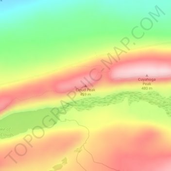
Name: Cloud Peak topographic map, elevation, terrain.
Location: Cloud Peak, Ontonagon County, Michigan, USA (46.81184 -89.73021 46.81194 -89.73011)
Average elevation: 345 m
Minimum elevation: 193 m
Maximum elevation: 481 m
Other topographic maps
Click on a map to view its topography, its elevation and its terrain.
Little Lake
USA > Michigan > Little Lake
Little Lake, Marquette County, Michigan, 49833, USA
Average elevation: 343 m
Grand Junction
USA > Michigan > Grand Junction
Grand Junction, Van Buren County, Michigan, 49056, USA
Average elevation: 206 m
Mackinac Island
USA > Michigan > Mackinac Island
Mackinac Island, Mackinac County, Michigan, 49757, USA
Average elevation: 195 m
Isle Royale National Park
Isle Royale National Park, Greenstone Ridge Trail, Houghton Township, Keweenaw County, Michigan, USA
Average elevation: 189 m