
Thank you for supporting this site ❤️
Make a donation
Make a donation
Monticiano topographic map
Click on the map to display elevation.
Thank you for supporting this site ❤️
Make a donation
Make a donation
About this map
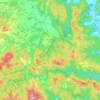
Name: Monticiano topographic map, elevation, terrain.
Location: Monticiano, Siena, Tuscany, 53015, Italy (43.07705 11.12512 43.16948 11.34102)
Average elevation: 372 m
Minimum elevation: 159 m
Maximum elevation: 785 m
Thank you for supporting this site ❤️
Make a donation
Make a donation
Other topographic maps
Click on a map to view its topography, its elevation and its terrain.